The Peter and Paul (St Petersburg) Fortress is the historical nucleus of the City on the Neva as well as one of its most interesting and beautiful architectural complexes. From as far away as the Gulf of Finland one can see the distant gilded spire of the fortress cathedral, one of the main features of the Leningrad skyline.
The Peter and Paul Fortress is the only surviving permanent fortified structure in the Russia planned and executed in strict accordance with the so-called bastion fortification system. Even in Western Europe only a few citadels built according to the same principles remain which are as well preserved as the fortress in Leningrad (for example, analogous structures at Lucca in Italy, Perpignan in France and Valletta in Malta). The main gate of the fortress on the Neva, the Sts Peter and Paul Cathedral, the Mint Works, the Defence Arsenal and other structures on its territory rank among the most interesting architectural landmarks of the eighteenth to the early twentieth century. In addition, the fortress is closely tied with great military, political and cultural events, important not only in the history of St Petersburg/Petro-grad/Leningrad, but in the history of the entire country: the Northern War, the assimilation of lands along the banks of the Neva, which in the eighteenth century were called “New Russian America”, the Decembrist Uprising, the social movement of the intelligentsia, the War of 1941—45…
Fortress — a type of permanent fortified structure (built of strong materials and serving as a means of defence during battle), the most essential and fundamental part of the fortress is the main rampart (an enclosed fence containing gate openings).
Bastion fortification system, — a method of building a fortress in which the main rampart consists of so-called bastion fronts (segments comprised of curtain walls and two adjacent demi-bastions).
The present guide will provide the reader with basic information about this unique cultural and historical complex. The description will be exclusively based on sources directly illuminating its almost 300-year history.
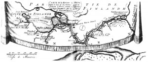
Map of the River Neva from Lake Ladoga to the Gulf of Finland, Where the Russian Emperor Peter I Ordered the City Si Petersburg Be Built; placed in ihe upper left corner of the engraving Map of the City and Fortification of St Petersburg, New Capital and Residence of the Russian Emperors, Built by the Emperor Peter I on Several Islands in the Gulf of Finland at the South of the River Neva (map published in Amsterdam in the beginning of the 1720s). In the right-hand part of the map at the source of the Neva, the notation: No’teburg, now Schliissel-burg; in the centre, on the right bank of the Neva, before St Petersburg, not far from the beginning of the Neva delta, the notation: Fortification on the Neva now destroyed (thai is, Nyenskans); to the left, in the Gulf of Finland, between two shoals, the indication: Passage to St Petersburg, and this passage is guarded on the south by a battery and Crohn-Schlott, and on the north by Kronstadt (The Russian Museum)
In 1617 Sweden completely closed off Russia’s access to the Baltic Sea by annexing territories to the south and north of the Neva, i.e., the Izhora Land (Ingria or Ingermanland) and Karelia. In 1699 a Russian-Danish-Saxon anti-Swedish coalition was organized. In February 1700 Saxony declared war against Sweden. In March Denmark did the same, and in August Russia followed suit. Later on Poland, Prussia, Hannover, Mecklenburg and Turkey also partook in this war, which became known as the Northern War. In October 1702 Russia stormed the island at the source of the Neva, and took the Swedish fortress Noteburg, which had been founded under the name of Oreshek (the Nut) in 1323 by the people of Novgorod. In April 1703 from this fortress, now called Schlusselburg, a campaign was launched downstream along the Neva under the command of Field-marshal Boris Sheremetev, one of the closest associates of Tsar Piotr Alexeye-vich (Peter I called the Great). At this time the Tsar wrote Sheremetev the following: “Time, time, time. Don’t give the enemy a chance to anticipate us.”
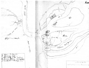
Map of the earthen St Petersburg Fortress — detail of the map Petersburg Island and Currents of the Neva as far as Nyenskans. The lower edge of the detailed drawing corresponds to the northern direction of the actual locality (Library of the USSR Academy of Sciences)
Moving quickly to the west, at the end of April Russian forces sieged the fortress Nyenskans, built by the Swedes a little above the Neva delta, on a cape at the confluence of the Neva and its largest right-wing tributary, the Okhta. By May 1 Nyenskans had surrendered and was immediately renamed Schlottburg. On May 7 the Swedish squadron, standing at the Neva Inlet near the mouth of the Bolshaya (Large) Neva, was attacked by a Russian detachment equipped only with simple boats. The Swedish fleet, which formerly had maintained complete dominion over the Baltic, lost two frigates. This was the first naval victory in the history of Russia.. In order to consolidate Russia’s position on the Gulf of Finland, a military council summoned by Peter the Great made the decision not to reinforce Schlottburg, but rather to build a new fortress nearer to the sea at a point which could be defended by means of natural barriers better than at the cape formed by the Neva and Okhta. Soon thereafter a small island was selected for this purpose located on the Neva delta to the west of Schlottburg and named “het Mooiste Lust Eiland” — “the Happiest Island”, the name coming from the Dutch as Peter the Great was fond of that language. After the construction of a fortress which occupied the entire island, it remained without an official name until the end of the eighteenth century. In the nineteenth and early twentieth centuries it was called Fortress Island, and subsequently received the name it bears today — Zayachy (Hare) Island, which is the translation of the name given the island by the Finnish-speaking portion of the local population in the seventeenth century.

The new fortress, whose construction of wood and earth was begun already in May 1703, soon became the centre of Russia’s activities on the Neva delta and, at the same time, the main stronghold of the Russian army in Ingria. The architect of the fortress is unknown. Some scholars suggest that it was designed by the French engineer Joseph Gaspard Lambert, a participant in the Neva campaign.
On June 29, 1703, a small wooden church was dedicated to the Apostles Peter and Paul in the centre of the unfinished fortress, and the fortress itself was named in the Dutch manner — St Pietersburg. Very quickly the short form of the name came into use, Pietersburg, as well as the names pronounced in the German manner, St Petersburg and Petersburg. Europeans followed attentively the swift movements of the Russian troops and, of course, well understood Peter’s intentions. The European press printed a whole line of news about the events on the Neva delta. This information was translated and circulated regularly in the first Russian newspaper Vedomosti, which began to be published on January 2, 1703, in Moscow.
On August 24 Vedomosti published a report from Riga about how Peter the Great “…has commanded that a city and fortress be built right on the sea not far from Schlottburg, so that in the future all goods destined for Riga, Narva and Schantz [Nyenskans] could find harbour there, and Persian and Chinese goods would come in there as well”. Finally, on October 4, the readers of Vedomosti were informed of the following in a report from Riga: “His Royal Highness, upon taking Schlottburg, ordered that a new and excellent fortress be built on an island one mile from the former in the direction of the Eastern [Baltic] Sea. The fortress is to consist of six bastions constructed by 20,000 labourers and to be named in honour of the ruler himself — Petersburg.” It is interesting to note that the way the city was named is explained in precisely the same way in both the famous Dictionnaire universel de commerce (1723) by the French lawyer and economist Jacques Savary (called Savary des Bruslons) and in the Concise Synoptic Description of St Petersburg by Andrei Bogdanov, the first Russian description of the newly built city.
Throughout almost the entire summer of 1703 the weather on the Neva delta was very cold and windy and the swampy islands on the river seemed even more damp than usual. Scurvy raged in the Russian camp. The Swedish forces held the mouth of the Neva within the sights of their guns until October. Nevertheless, work on “het Mooiste Lust Eiland” did not stop for a single day. As early as September it was possible to transfer the general headquarters and main Russian military camp from Schlottburg and establish it within the protective walls of the new fortress located on the big island nearby. As soon as the Swedish war ships left for their winter harbour at Vyborg, Peter the Great embarked for the long island of Kotlin located in the Gulf of Finland at the entrance to the Neva Inlet. Near its eastern end (where subsequently the fortress city of Kronstadt was built) he chose the site for construction of a fort which was to become the “naval lock” of the Neva mouth (in the early eighteenth century the latter was considered to be located right near Kotlin).
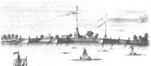
Erected in less than one year, the earthen St Petersburg Fortress took the shape of a multi-angled rampart, closed on all sides, with defensive bastions, a design which incorporated elements of all the then major Western European fortification systems: French, Dutch and German. And this is not surprising since in the beginning of the eighteenth century Russian engineers were familiar with the original works of the most prominent European military engineers, the Frenchman Sebastien Leprestre de Vauban, the Dutchman Menno van Coehoorn, and the German Georg von Rimpler. In 1709 and 1710 the major essays of Coehoorn appeared in Russia in translation under the title New Fortified Structures Built on Wet or Low Lands … the Manner in Which It Is Proper to Build a Fortress Today on the Sea or on Rivers. Somewhat later there appeared the Russian translations of the essays of Rimpler and Vauban.
The St Petersburg Fortress consisted of six bastions and six curtain walls. Its overall plan — an irregular hexagon with bastion points at each exterior corner — followed the approximate contour of the island from east to west. Three of the six bastions stood on its southern bank, lapped by the waves of the Neva, the other three, on its northern shore, were protected by a small fork of the Neva.
Peter the Great personally observed the erection of one of the three southern bastions, the one which is situated higher than the other two on the Neva, and which was named the Tsar Bastion. The Tsar delegated the task of observing the erection of the remaining five bastions to five of his closest associates, and the bastions were named after each one correspondingly: the central southern was called the Naryshkin Bastion; the lower southern, the Trubetskoi Bastion; the lower northern, the Zotov Bastion; the central northern, the Golovkin Bastion; and the upper northern, the Menshikov Bastion. Along the length of the island a narrow canal was dug to supply the garrison with water in case of siege. In the curtain wall connecting the Tsar and Menshikov Bastions, the main gate was built, the approach to which was protected by a transversal moat and a ravelin. A pontoon bridge was installed between the small gate in the left face of the ravelin and the large island across the fork of the Neva and named the Krasny (Red or Beautiful) Bridge. The fork itself served as the main docks for military vessels for more than ten years. The cavalier was built in the Golovkin Bastion. Inside the fortress several other buildings for military use were erected as well, and in addition to these a small wooden Lutheran Church of St Anne, which stood on the site until 1710. On May 7, 1704, exactly one year after the naval victory near the mouth of the Large Neva, Peter the Great again arrived at Kotlin Island, and with a three-day ceremony marked the completion of construction of the fort Crohn-Schlott, whose guns reigned over the fairway near the southern shore of the island. One of Peter’s close associates, Alexander Kikin wrote him a humorous account of the commander of the Swedish fleet who “acted very wisely in deciding to leave this place for good last year.” At last an access had been opened for Russia onto the vast expanses of the sea, although there remained more than seventeen exhausting years of battle before ultimately securing it by means of a peace treaty with Sweden.
Crohn-Schlott became a reliable guard for the sea approaches to the Neva delta. And the delta itself was protected by the earthen St Petersburg Fortress. On May 14, 1704, the first gun salute from the walls of the new fortress took place in honour of the Russian victory on Lake Peipus, and served as well to mark the end of its construction. Under the protection of St Petersburg, on the site to which the Russian military camp had been transferred from Schlottburg in the autumn of 1703, a new Russian city began to grow. It took on the names St Pietersburg (Pietersburg) and St Petersburg (Petersburg), but early on the city received the popular nickname “Piter”. Accordingly, the big island, on which the main part of the new city was originally situated, came to be called St Petersburg (Petersburg) Island. Today the island is called Petrogradsky from the name “Petro-grad” which the city officially received in 1914, after the start of World War I. Since 1710 the fortress itself was officially called the St Petersburg (Petersburg) Fortress. With time it also gained unofficial names such as the “Peter and Paul Fortress” after the cathedral located in its centre.


